Charles C. Mitchell, Auburn University
Charles H. Burmester, Auburn University
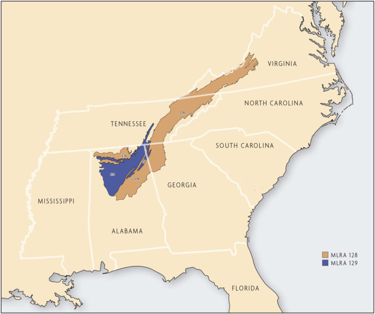
The Tennessee Valley and Sandstone Plateau region of northern Alabama is part of two major land resource areas (MLRA) as defined by USDA Natural Resources Conservation Service (NRCS): MLRA 128 (Southern Appalachian Ridges and Valleys) and MLRA 129 (Sand Mountain) (Figure 17.1). MLRA 128 is located in Tennessee (36 percent), Alabama (27 percent), Virginia (25 percent) and Georgia (12 percent). MLRA 129 is located mostly in Alabama (96 percent) with small parts in Georgia (3 percent) and Tennessee (1 percent). MLRA 128 has a land area of 21,095 square miles (13,500,800 acres). This area of the Southern Appalachian Mountains is highly diversified with many parallel ridges, narrow valleys and large areas of low, irregular hills. Elevations range from 630–2,300 feet. The Tennessee Valley is one of the broader valleys in the region and was formed primarily from eroded limestone. The ridges and plateaus are capped with sandstone and shale. The climate of the region is moderate, with annual frost-free periods near 245 days. Rainfall is relatively abundant, with annual precipitation averaging 41–55 inches. Annual rainfall in the region is evenly distributed throughout the year. [5, 13]
The limestone valley soils tend to be deeper, with more silt and clay than soils formed from sandstone and shale on the plateaus. Locally, farmers refer to the more arable limestone valley soils as “red land,” in reference to their red color. An example is the Decatur soil series. The soils of the Tennessee Valley may have more than 20 feet of unconsolidated material over the limestone bedrock. On eroded knolls, cherty limestone outcroppings may be found, and in some fields there are depressions and sinkholes that resulted from dissolving limestone underneath.
The Tennessee Valley was a center of plantation-style cotton production in the antebellum period. Sharecropping dominated the post-Civil-War era until World War II. Throughout the 19th and 20th centuries, traditional cultivation practices included fall moldboard plowing, winter fallow, spring disking or chisel plowing (post World War II), harrowing and planting followed by several mechanical cultivations for weed control. Erosion, sometimes severe, was an accepted sacrifice for row crop production. Even after terracing and contour farming practices were introduced in the 1930s, erosion continued and perhaps increased with larger equipment in the 1960s, 1970s and 1980s. Locals seemed to accept that the Tennessee River and its tributaries flowed red with late-winter and early-spring rains.
In spite of almost 200 years of continuous cultivation and some severe erosion, these valley soils remain relatively productive. The USDA estimates that about 6 percent of the Tennessee Valley and Sandstone Plateau region is in cropland, but the Tennessee Valley and Coosa River valley of northern Alabama are intensively cultivated. In 2012, 549,507 acres of row crops were planted in the nine Alabama counties contiguous to the Tennessee River [12]. The sandier sandstone plateau soils on the sandstone ridges and plateaus have not fared as well. They are often acidic and infertile, with the depth to the sandstone bedrock anywhere from a few inches to several feet. A history of soil erosion has forced some of these soils out of cultivation entirely. The soils were not extensively cultivated until the late 19th and 20th centuries, when the use of fertilizers and ground limestone greatly enhanced their productivity.
MLRA 129, Sand Mountain, is located primarily in northeastern Alabama, includes 8,030 square miles (5,139,200 acres) and is one of the broader ridges in the region. Fields on the plateaus are typically much smaller than those in the valleys and are more dissected by terraces and contours. Most of Cullman, Blount, Marshall and Dekalb counties in Alabama are on the sandstone plateaus. These counties had 55,984 acres of row crops and 118,378 acres of hay land in 2012 [12]. The steeper terrain and shallow soils of the Sand Mountain region make poultry broiler production more economically viable than row-crop farming. Poultry production increased rapidly in this region in the 1970s and 1980s. Land was converted from row crops to pastures and hayfields where broiler litter could easily be applied at any time of the year. Most of the Sand Mountain region is now industrialized, with a large percentage of the rural population earning a non-farm-related income.

