Madalene Ransom, USDA-NRCS
James Frederick, Clemson University
Gene Hardee, USDA-NRCS
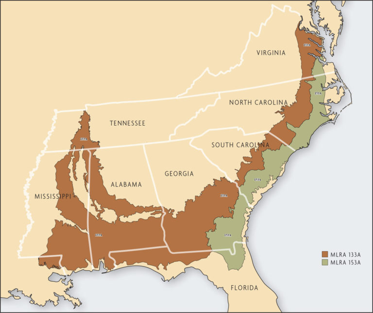
The Southern Coastal Plain and the Atlantic Coast Flatwoods major land resource areas (MLRAs) extend along the southeast coast of the United States from Virginia to Mississippi and to the eastern tip of Louisiana, excluding the Tidewater regions of Virginia and North Carolina as well as the Florida peninsula (Figure 18.1). MLRA 133A, the Southern Coastal Plain, has a land area of 106,485 square miles (68,150,400 acres). MLRA 153A, the Atlantic Coast Flatwoods, has a land area of 28,720 square miles (18,380,800 acres).
Land use in the Southern Coastal Plain and the Atlantic Coast Flatwoods is similar, with both predominantly forested: 64 percent of total area for the Southern Coastal Plain and 67 percent for the Atlantic Coast Flatwoods. Crops are produced on 11,585,600 acres in the Southern Coastal Plain (17 percent of the total area) and on 2,757,100 acres of the Atlantic Coast Flatwoods (15 percent of the total area) [16].
As their names imply, the two MLRAs have relatively flat topography. The elevation in the Atlantic Coast Flatwoods ranges from 25–80 feet, while the elevation in the Southern Coastal Plain ranges from 80–650 feet. Although the potential for water erosion exists, especially on the Southern Coastal Plain soils, most of the topography is relatively flat. Thus, adoption of conservation tillage for erosion control has been slower than on the steeper slopes of the Southern Piedmont (MLRA 136) and other regions of the Southeast.
The climate in both MLRAs is mild with a long growing season. Annual frost-free periods range from 200 days in northern areas to 305 days in southern areas. Rainfall is abundant, with annual precipitation of 44–57 inches in the Atlantic Coast Flatwoods and of 41–60 inches in most of the Southern Coastal Plain. An important feature of the annual rainfall distribution is that it occurs in a bimodal fashion, meaning that annually there are two rainy periods. Peak rainfall occurs in the summer, with frequent thunderstorms and occasionally tropical storms. The highest average annual rainfall occurs during late summer. A second, smaller rainfall peak occurs in early spring.
Though rainfall is plentiful, the seasonal pattern of precipitation leads to periods of plant water-deficit stress in most years for summer-grown crops. A considerable amount of the total summer rainfall comes from heavy thunderstorms, and there are often long periods between rainfall events. Rain-free periods of 21 days occur in most years during the growing season [12].
Potential evapotranspiration is a calculated estimate of the amount of water plants use plus water that evaporates. During the months of April, May, June and July, the evapotranspiration, on average, exceeds rainfall. For the period from 1985–2003, the cumulative difference between evapotranspiration and accumulated rainfall for those four months was approximately 10 inches, or 0.53 inches each year [2]. On average for those years, rainfall was about the same as evapotranspiration during August, September, October, November and March, while rainfall exceeded evapotranspiration during December, January and February.
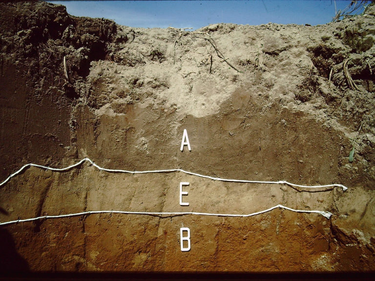
Compounding the problem of summer precipitation deficits, most soils in the region are sandy in texture with low organic matter and low water-holding capacity. These soils were formed in marine sediments. The Tifton and Norfolk soil series are found throughout the Southern Coastal Plain. The sandy-soil surface layer, the A horizon, typically has a highly leached layer, the E horizon, below it that can form dense hardpans (Figure 18.2). The E horizon is a mineral horizon made up of sand and silt particles that are coarser than the A horizon. For many crops, it needs to be fractured for optimal production. The sands in the A and E horizons tend to be many different sizes and will compact due to rainfall even without tillage or traffic. Below the E horizon is the B horizon, which generally has a sandy-clay loam texture that gives it more water-holding capacity than either the A or E horizons. However, these subsoils are often acidic, which reduces rooting depths and the volume of soil plant roots can explore for water and nutrients [13].
On the other hand, many of the soils are poorly drained, especially in the Atlantic Coast Flatwoods. Seasonal high water tables and surface ponding can significantly reduce crop yields. Subsurface tile drains are used on approximately 800,000 acres in North Carolina (25 percent of cropland), 175,000 acres in South Carolina (25 percent of cropland) and 230,000 acres in Georgia (8 percent of cropland) [15].


